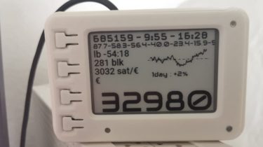
A E-ink ticker that shows usefull information about bitcoin
bitcoin-ticker bitcoin-ticker is a E-ink ticker that shows usefull information about bitcoin. Due to the limited refresh lifetime, new information is currently shown every 5 minutes and whenever a new block arrives. Hardware I’m currently working on a 7.5 inch version with the following e-Paper: The config.ini needs the following settings when using the 7.5 inch: epd_type = 7in5_V2 orientation = 270 Usage Ticker view The Tickers the following information: Block height, Mean block intervall in minutes, Time Minimal Block […]
Read more