A Product lead’s Guide to NLP solutions
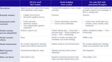
A not-too-technical guide to find the ideal text analytics solution for your application If you are leading a digital product development that transforms unstructured text into value for your internal / external users, yet have difficulties navigating through the Natural Language Processing (NLP) solutions or making the build-or-buy decision, this article helps you identify key decision criteria to make informed choice.
Read more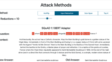
Adversarial Attacks on Question Answering
The recent explosion of Question Answering datasets and models is pushing the boundaries of QA systems and making them widely used by the general public in virtual assistants or chatbots (Rogers et al., 2021). However, it is well-known that is possible to “trick” machine learning systems. For instance, Goodfellow et al. (2014) shows that a clear picture of a panda can be modified with some invisible noise for humans that makes the ML model classify it as a
Read more
Getters and Setters: Manage Attributes in Python
If you come from a language like Java or C++, then you’re probably used to writing getter and setter methods for every attribute in your classes. These methods allow you to access and mutate private attributes while maintaining encapsulation. In Python, you’ll typically expose attributes as part of your public API and use properties when you need attributes with functional behavior. Even though properties are the Pythonic way to go, they can have some practical drawbacks. Because of this, you’ll […]
Read moreIntroduction to Aggregate and Transform functions in Apache Spark
Spark SQL functions, such as the aggregate and transform can be used instead of UDFs to manipulate complex array data containing nested structures.
Read more

CI/CD for ML Projects
CI: Continuous Integration CD: Continuous Deployment/Delivery
Read more
Building a GPT-3 Powered Discord Support Bot
Discord is becoming a popular platform for open source projects and companies to manage their developer communities. These Discord servers are where developers can go to get their questions answered quickly. Some support channels are extremely busy with the same questions being asked and answered over and over again. I figured that answering these questions might be something that GPT-3 could do really well! So I decided to spend a couple hours to build the bot — this article talks […]
Read more