LiDAR-based Place Recognition using Spatiotemporal Higher-Order Pooling

Locus
This repository is an open-source implementation of the ICRA 2021 paper: Locus: LiDAR-based Place Recognition using Spatiotemporal Higher-Order Pooling.
More information: https://research.csiro.au/robotics/locus-pr/
Paper Pre-print: https://arxiv.org/abs/2011.14497
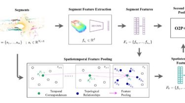
Method overview.
Locus is a global descriptor for large-scale place recognition using sequential 3D LiDAR point clouds. It encodes topological relationships and temporal consistency of scene components to obtain a discriminative and view-point invariant scene representation.
Usage
Set up environment
This project has been tested on Ubuntu 18.04 (with Open3D 0.11, tensorflow 1.8.0, pcl 1.8.1 and python-pcl 0.3.0). Set up the requirments as follows:
- Create conda environment with open3d and tensorflow-1.8 with python 3.6:
conda create --name locus_env python=3.6
conda activate locus_env
pip install -r requirements.txt
- Set up python-pcl. See
utils/setup_python_pcl.txt.