A Python package for delineating nested surface depressions from digital elevation data
lidar
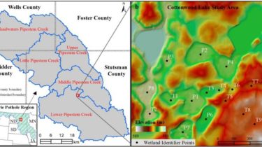
lidar is Python package for delineating the nested hierarchy of surface depressions in digital elevation models (DEMs). It is particularly useful for analyzing high-resolution topographic data, such as DEMs derived from Light Detection and Ranging (LiDAR) data.
GitHub repo: https://github.com/giswqs/lidar
Documentation: https://lidar.gishub.org
PyPI: https://pypi.org/project/lidar
Conda-forge: https://anaconda.org/conda-forge/lidar
Open in Colab: https://gishub.org/lidar-colab
Free software: MIT license
lidar is a Python package for delineating the nested hierarchy of surface depressions in digital elevation models (DEMs). In traditional hydrological modeling, surface depressions in a DEM are commonly treated as artifacts and thus filled and removed to create a depressionless DEM, which can then be used to generate continuous stream networks. In reality, however, surface depressions in DEMs are commonly a combination of spurious and actual terrain features. Fine-resolution DEMs derived from Light